
LINCOLNSHIRE / CIRCULAR WALK
Wanderlust Way
A full-day circuit from Bradley Woods through villages and farmland on the edge of the Lincolnshire Wolds. Use the interactive route map to plan the 33.3 km walk and your return to the same starting point.
🔒 Travel Club Members Only
You’re just one step away from unlocking this feature. Join the FREE Days Out Now Travel Club to access holiday builders, GPX downloads, attraction offers, exclusive hidden gems and much more.
At a glance
Why this walking route is worth doing
The appeal of this walk is the changing countryside over a proper day on foot: woodland at Bradley, open farmland and a succession of small Lincolnshire villages. The mapped circuit covers 33.3 km, or approximately 20.7 miles, and returns to Bradley Woods.
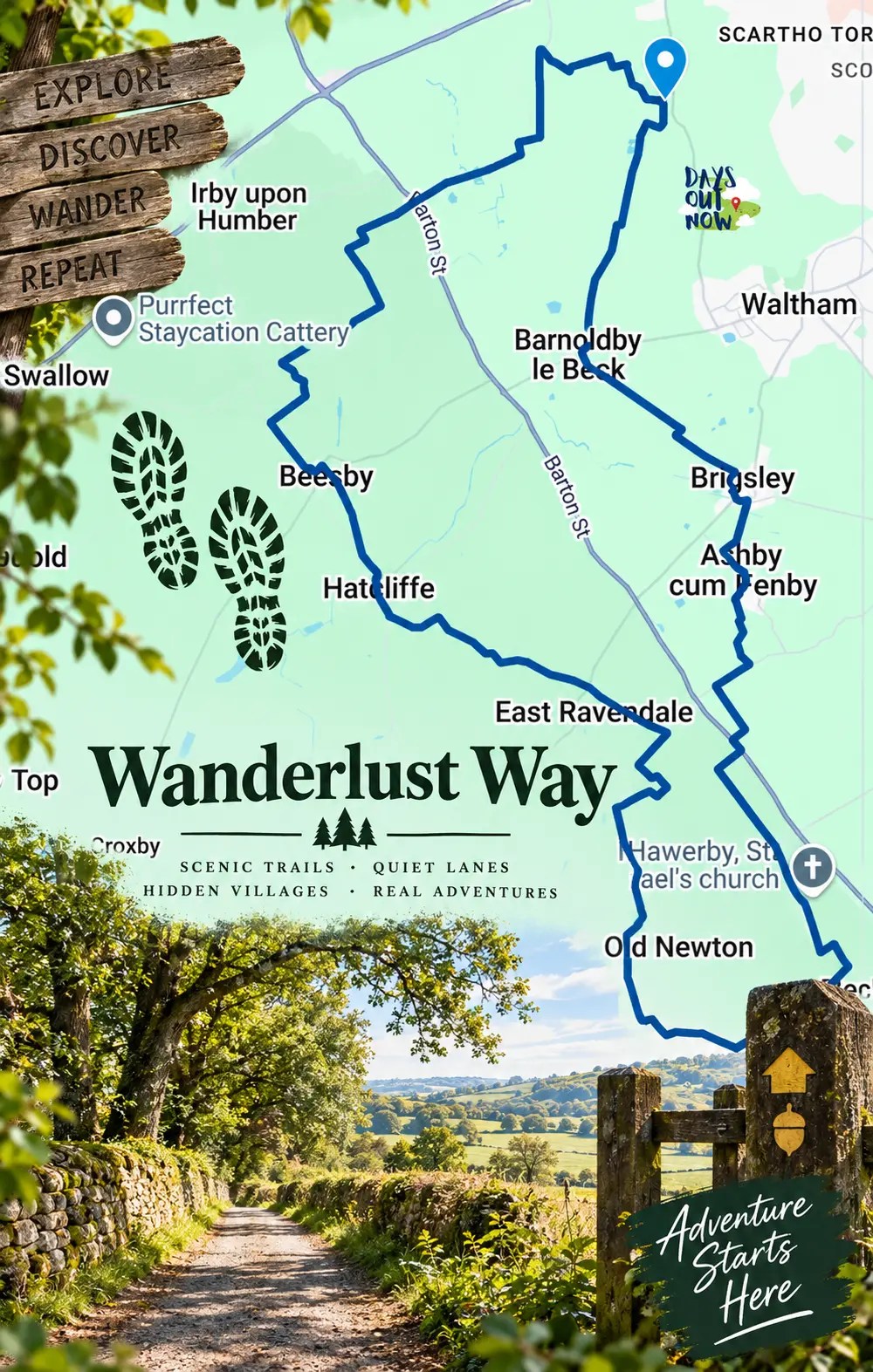
The route reaches south towards Wold Newton, taking in Beelsby, Hatcliffe and East Ravendale on its western side, then Ashby cum Fenby, Brigsley and Barnoldby le Beck on the return. It suits walkers comfortable spending most of the day outside and covering a substantial distance.
This guide explains the route’s broad sequence and how to plan the day. The interactive map is the route reference; the village overview below is not a set of turn-by-turn directions.
A long loop from Bradley Woods
Read the circuit anti-clockwise from the marked start: Bradley Woods → Beelsby → Hatcliffe → East Ravendale → Wold Newton area → Ashby cum Fenby → Brigsley → Barnoldby le Beck → Bradley Woods. Open the map at each section to see the connecting paths rather than drawing straight lines between villages.
Allow enough time
At an average moving pace of 4 km/h, 33.3 km takes roughly 8 hours 20 minutes before breaks. At 3 km/h it takes about 11 hours. These are distance-based planning estimates, not measured completion times; terrain, navigation and conditions add time. Choose a day with sufficient daylight for your own pace.
Who will enjoy it?
This is a useful choice for walkers seeking a long countryside circuit with several villages along the way. The distance makes it a demanding outing even without mountain terrain. Build up with shorter walks first if you are unsure about spending a full day on foot.
Plan another day out
Compare more UK walking routes if you want a shorter outing, or explore our England destination guides to build a longer break.
Where to stay before or after the walk
Grimsby: use the town as a base for a night before the walk, then arrange your journey to Bradley Woods. For a 20.7-mile day, check breakfast times and ask whether you can leave a car or luggage after checkout. Hotel parking is separate from parking at the walk start.
Ashby cum Fenby: Hall Farm Hotel & Restaurant, on Ashby Lane (DN37 0RT), offers hotel rooms and dining in one of the villages visited by the circuit. It is an option to investigate for a countryside stay. Check room availability, meal service and the exact walking connection before booking; this is not a confirmed halfway stop or an endorsed two-day itinerary.
One night or two? Staying the night before gives you time for an early start. A second night avoids combining a very long walk with a long drive home. If you want to split the circuit, first measure both days on the map and arrange accommodation and any transfers around that split. The accommodation searches below let you compare dates and prices; accommodation is booked separately.
Mapped and ready
See the real route before you set off
Open the interactive map before setting off and save an offline map for the walk.
Step-by-step directions
Follow the route
Bradley Woods to Beelsby
Begin at the Bradley Woods start marker. The western side of the mapped circuit heads towards Beelsby, passing through the countryside south of Irby upon Humber. Use the detailed map for the connecting paths and junctions; this section summary does not describe every turn.
Beelsby, Hatcliffe and the southern loop
From Beelsby, the mapped circuit continues through Hatcliffe and towards East Ravendale. Its southern loop reaches the Wold Newton area before turning back north. Check the complete curve of the line on the map: going directly between the named villages would shorten or change the plotted walk. Plan food and water for this part of the day rather than assuming refreshments will be available.
Return via Ashby cum Fenby and Brigsley
The eastern side of the loop brings you back north through the Ashby cum Fenby area, Brigsley and Barnoldby le Beck before returning to Bradley Woods. Keep enough time and energy for this final stretch: the return to the start is part of the full 20.7-mile distance. Consult the map closely at village exits and road connections.
Useful overnight bases
Where to stay for the Wanderlust Way
Grimsby — a base before or after the walk
Grimsby, Lincolnshire, United Kingdom
Compare places to stay →Ashby cum Fenby — countryside accommodation
Ashby cum Fenby, Lincolnshire, United Kingdom
Compare places to stay →Accommodation links are affiliate links. Days Out Now may earn a commission at no extra cost to you. Prices and availability are set by the booking provider.
Before you go
Practical information
The start and finish are at Bradley Woods, near Grimsby. Use the details below to plan parking, food, transport and a realistic finishing time.
The distance comes from the plotted map and is approximate. This guide has not been checked by a recent on-foot inspection; confirm current path access and conditions before setting out.
Parking
Small car park at Bradley Woods; limited spaces
Tickets and booking
There is no ticket sold through this guide for the walk. Check parking notices on arrival. Book any overnight stay or restaurant separately and check cancellation terms, breakfast and late-arrival arrangements.
Seasonal considerations
Choose sufficient daylight for a full day on foot. Check the forecast and recent rainfall before leaving; allow extra time when conditions slow your pace.
Toilets and refreshments
Carry a packed lunch, snacks and sufficient water. Potential meal stops include Hall Farm Hotel & Restaurant in Ashby cum Fenby and The Ship Inn in Barnoldby le Beck. Check service times and reserve if needed; do not rely on either for an unplanned refill or toilet stop. Public toilets along the full circuit have not been confirmed.
Terrain
A 33.3 km (20.7-mile) countryside circuit linking woodland, farmland and villages, with road sections and crossings. Surface condition can change after rain; use footwear with good grip.
Accessibility
The full circuit has not been surveyed for step-free access, gates or stiles. Its length and countryside sections mean it should not be presented as wheelchair- or pushchair-accessible.
Facilities
Bradley Woods has a small car park and a bird-feeding area. The published facilities list does not confirm toilets or a café at the start; make a toilet stop before arriving.
Dogs
Consider whether your dog can manage 20.7 miles. Carry its water and keep it under close control, using a lead around livestock and roads. Check accommodation and restaurant dog policies before booking.
Public transport
Arrange the final journey to Bradley Woods and the return journey before travelling. This guide does not confirm a bus serving the exact start or a late service after the walk; allow for a pre-booked taxi if needed.
Road conditions, tolls or permits
Bradley Woods is south of Grimsby, off the A46 on the B1444. The small car park on entering the woods has about eight spaces. Check signs for charges and vehicle-access times; do not block gates or verges if it is full.
Safety
Download a navigation backup, carry a charged phone and power bank, waterproofs and a headtorch, and tell someone your route and expected return. Check crossings and current rights of way before departure; a plotted line does not confirm access or current path conditions.
Important cautions
At 4 km/h, walking time alone is about 8 hours 20 minutes; at 3 km/h, about 11 hours. Add breaks and navigation time. These are estimates from distance, not recorded walking times.
Days Out Now Free Travel Club
Take the useful bits with you
Join free for GPX route files and access to Days Out Now member benefits, including eligible days-out savings.
Useful answers
Wanderlust Way FAQs
How long is the walk?
The supplied map measures approximately 33.3 km, or 20.7 miles, for the full circular route.
How much time should I allow?
Allow a full day. At 4 km/h, moving time alone is about 8 hours 20 minutes; at 3 km/h it is about 11 hours. Add breaks and allow for conditions and navigation.
Where does the walk start?
The marked start and finish are at Bradley Woods, near Grimsby. There is a small car park, with limited spaces.
How difficult is the route?
Treat this as a strenuous day because of its length. This is a distance-based assessment, not an official route grading or a recent condition report.
Can I take my dog?
The complete circuit has not been checked here for dog restrictions or obstacles. Check the route before taking a dog, allow for the full distance, carry water and keep it under close control around livestock.
Is the route accessible or suitable for pushchairs?
Step-free access, gates and stiles have not been assessed for the full route. Do not assume this long countryside circuit is suitable for wheelchairs or pushchairs.
Are there toilets and refreshments?
Do not rely on unverified village facilities. Carry food and water, and check the opening times of any intended refreshment stop before leaving.
What should I know before setting off?
Study the full mapped circuit, particularly road sections and crossings, and check current access. Carry an offline navigation backup, appropriate clothing and sufficient phone battery.
When should I walk it?
Choose a day with enough daylight for your own pace and check the weather. Short winter days make a circuit of this length harder to complete in daylight.


For local businesses
Own somewhere visitors should discover near Lincolnshire?
Showcase a relevant place to stay, food stop, attraction or activity while Days Out Now keeps editorial control.


Leave a Reply