
PEAK DISTRICT / CIRCULAR WALK
Find places to stay nearby
Choose a base that fits your visit to Edale, Derbyshire, United Kingdom.
Compare places to stay near Edale →Live prices from Booking.com. Affiliate link: Days Out Now may earn a commission at no extra cost to you.
Affiliate links: Days Out Now may earn a commission at no extra cost to you. Prices and availability are set by the booking provider.
Edale Circular Walk: Woolpacks & Jacob’s Ladder
Climb Grindsbrook Clough, explore the Woolpacks and descend Jacob’s Ladder on this 8-mile Edale circular. A challenging hill day with rocky scrambling, open moorland and a return through Upper Booth.
Unlock your free Travel Club benefits
Join free for available GPX walking tracks and an additional 10% off eligible Love to Visit bookings. Merlin products are excluded.
Already subscribed? Open the personal unlock link in your Days Out Now welcome email in this browser, then return here. You do not need to join again or create a WordPress account. Check spam or junk if you cannot find the email. If your older welcome email has no unlock link, contact us from your subscribed address for help.
At a glance
Why this walking route is worth doing
The Woolpacks are the reason to leave plenty of time for this walk. Their scattered gritstone shapes turn Kinder Scout’s southern slopes into a landscape of boulders, narrow gaps and changing views.
Getting there takes effort. From Edale, Grindsbrook Clough leads uphill over increasingly rocky ground, with scrambling before the plateau. The circuit continues west past Crowden Tower and through the Woolpacks, then descends Jacob’s Ladder.
The Pennine Way brings you home through Upper Booth. Keep some energy for the field paths: reaching the bottom of Jacob’s Ladder does not mean all the climbing is over. This is a substantial hill day for walkers comfortable with rough terrain and navigation.
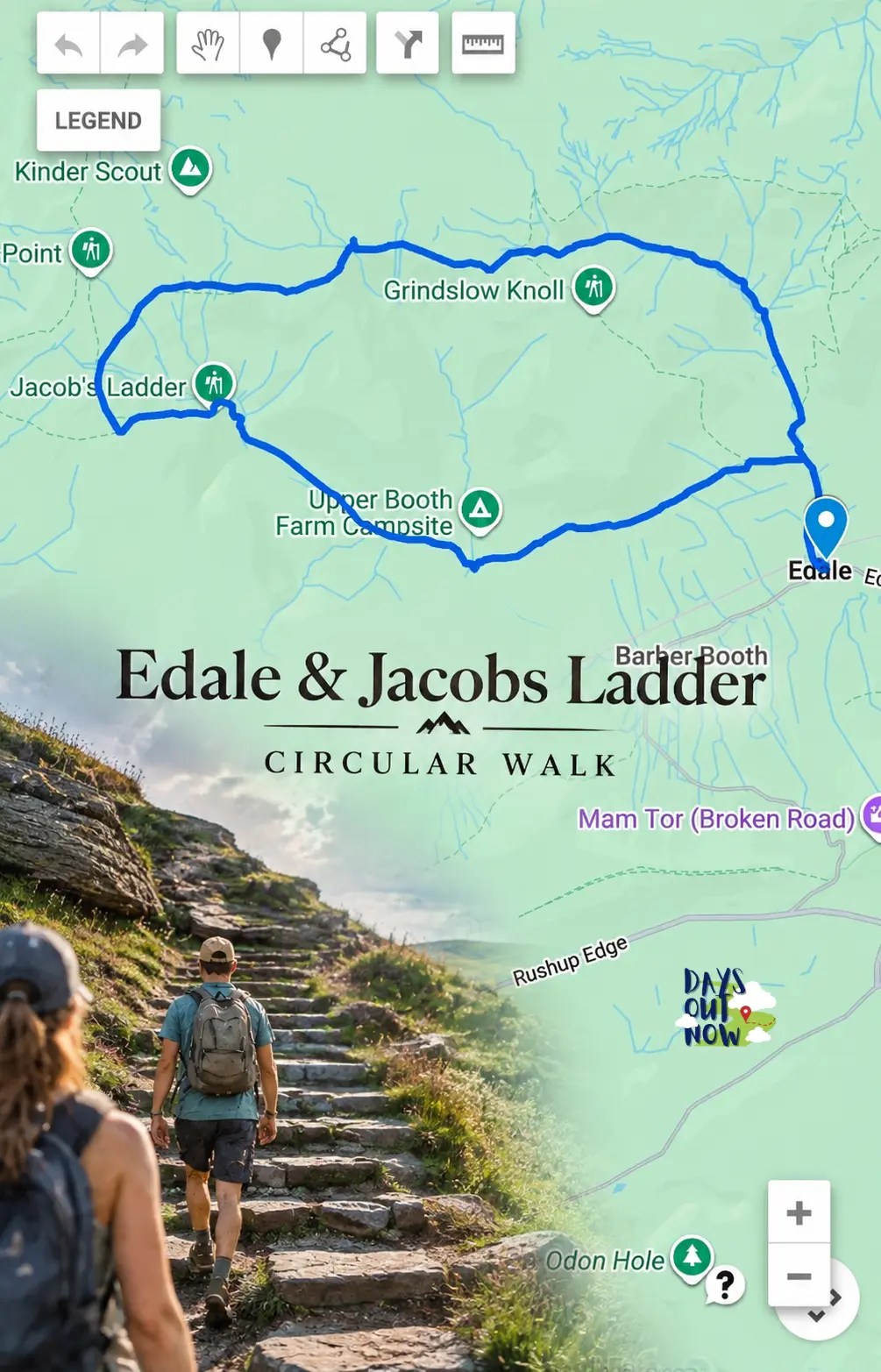
Edale → Grindsbrook Clough → Crowden Tower → Woolpacks → Noe Stool → Jacob’s Ladder → Upper Booth → Edale.
Follow Grindsbrook uphill and Jacob’s Ladder downhill. The saved map measures 12.95 km. This circuit visits Kinder’s southern plateau; it does not include Kinder Scout’s actual summit, Kinder Low trig point or Kinder Downfall. Those require separate route planning and extra time.
Mapped and ready
See the real route before you set off
Open the interactive map before setting off and save an offline map for the walk.
Step-by-step directions
Follow the route
Edale to Grindsbrook Clough
From the village car park, walk uphill through Edale towards The Old Nag’s Head. Take the signed Grindsbrook footpath beyond the pub and cross the footbridge to join the valley path. Keep the Pennine Way towards Upper Booth for your return.
Route advice: Use the village facilities before heading uphill.
Climb Grindsbrook Clough
Follow the valley upstream as the ground becomes steeper and rockier. The upper section requires scrambling: expect to use your hands and choose footholds carefully. At the head of the clough, reach the plateau and confirm your position before continuing west.
Route advice: Reassess difficult water crossings and slippery rock; do not push beyond your group’s ability.
Cross towards Crowden Tower
Head west along the southern plateau towards Crowden Tower. Cross Crowden Clough and continue towards the rock formations. Check the map at junctions: descending Crowden Clough would take you away from the planned Woolpacks circuit.
Route advice: Stop to check directions somewhere secure, away from drops.
Explore the Woolpacks
Continue west through the Woolpacks towards Noe Stool. Enjoy the rock shapes while keeping track of the route as paths weave between them. Take time here rather than chasing a walking pace.
Route advice: After exploring or stopping for photographs, relocate your position before moving on.
Descend Jacob’s Ladder
From Noe Stool, join the Pennine Way towards Jacob’s Ladder. Follow the descent to the cairn above its steep steps, then continue down to the bridge at the foot of the climb.
Route advice: Leave space between walkers on the steps, particularly when the stones are wet.
Upper Booth and back to Edale
Follow the valley route to Upper Booth. Take the signed Pennine Way through the farm and across the fields towards Edale. The path returns beside The Old Nag’s Head; follow the village road downhill to the car park or station.
Route advice: Keep enough energy for the remaining field paths and their uphill sections.
Before you go
Practical information
The walk changes character several times: village road, valley footpath, rocky scramble, open moorland, stone steps and fields. Pause at each transition and confirm your next landmark. After a photo stop in the Woolpacks, relocate your position before moving on.
Give this walk its own day. For another outing, explore Burbage Rocks and Higger Tor. Plan a longer visit with our two-day Peak District road trip, or compare routes in the Peak District area guide.
Parking
Paid parking at Edale village car park. Check the current tariff on arrival and allow time for the full walk and stops. Council information: https://www.highpeak.gov.uk/article/864/Hope-Valley-Car-Parks
Tickets and booking
No attraction ticket is needed for the walking circuit. Parking, train travel, food and accommodation are separate costs.
Seasonal considerations
Choose good visibility and manageable wind. Wet rock changes the Grindsbrook ascent; snow and ice require winter hillwalking skills and equipment. Allow daylight for the full circuit, breaks and delays. Check the Peak District mountain forecast before departure.
Toilets and refreshments
Public toilets are at Edale’s main village car park; the railway station has no toilets. Check individual café and pub opening hours. National Park-operated visitor facilities in Edale closed in March 2025, so do not rely on the former visitor centre being open.
Terrain
Village lanes, uneven valley paths, a rocky scramble up Grindsbrook Clough, exposed moorland, steep stone steps and farmland.
Accessibility
The complete circuit is unsuitable for wheelchairs and pushchairs. It requires confident movement over steep, uneven rock. Judge suitability for children by their experience of comparable hill days, not age alone.
Facilities
Plan to carry food and water for the whole hill section. Edale is the place for services before and after the walk.
Dogs
Only suitable for dogs comfortable with a long, rocky hill walk and steep steps. Keep dogs on a short lead, follow local notices and take waste home. The National Trust asks visitors to protect livestock and ground-nesting wildlife.
Public transport
Edale station is on the Hope Valley line between Manchester and Sheffield, close to the village start. Check current trains and allow a generous return margin rather than relying on an exact finish time.
Safety
Carry walking footwear with reliable grip, waterproofs, a warm layer, food, water, a map and compass you can use, a charged phone with offline mapping, backup power, a headtorch and basic first aid. Tell someone your route and expected return. Reassess if water crossings, slippery rock or poor visibility exceed your group’s ability.
Important cautions
Grindsbrook requires scrambling and the Woolpacks can be difficult to navigate in low cloud. This is a mapped guide, not a claim of a recent on-foot survey. Follow current access notices and use the route stages alongside a suitable walking map.
Days Out Now Free Travel Club
Take the useful bits with you
Join free for GPX route files and access to Days Out Now member benefits, including eligible days-out savings.
Useful answers
Edale Circular Walk: Woolpacks & Jacob’s Ladder FAQs
How long is this Edale circular walk?
The saved route measures 12.95 km, approximately 8 miles. It returns to Edale via Upper Booth.
How much time should I allow?
Allow 5–6 hours, and longer for extended stops. Scrambling and navigation can slow progress; leave a margin for daylight and your return train.
Where does the walk start?
At Edale village car park, S33 7ZQ. Edale railway station is nearby.
Is this suitable for beginner hillwalkers?
It is a challenging circuit with a rocky scramble and moorland navigation. It is a poor choice for a first independent hillwalk.
Can I take my dog?
Only if your dog can manage a long rocky walk and steep steps. Keep it on a short lead, follow local signs and take waste home.
Is the route accessible or suitable for pushchairs?
No. Steep rocky ground, scrambling and steps make the full circuit unsuitable for wheelchairs and pushchairs.
Does this route visit Kinder Scout’s summit?
No. It visits the southern plateau but does not include the actual summit, Kinder Low trig point or Kinder Downfall.
Can I walk the loop in reverse?
Yes, but reversing it means descending the Grindsbrook scramble. Rocky downclimbing may feel harder than climbing up. These directions follow Grindsbrook uphill and Jacob’s Ladder downhill.
Is Jacob’s Ladder an actual ladder?
No. It is a steep stepped path. This circuit descends it after visiting the Woolpacks.


For local businesses
Own somewhere visitors should discover near Peak District?
Showcase a relevant place to stay, food stop, attraction or activity while Days Out Now keeps editorial control.
MAKE MORE OF YOUR DAY
Nearby places to visit, eat and stay
Nearby suggestions will load here.
MAKE MORE OF YOUR DAY
Explore more places on the map
Choose what you need, then use the map to compare locations and plan the rest of your day.


Leave a Reply