
LAKE DISTRICT / LAKESHORE WALK / COMPLETE ROUTE
Buttermere Circular Walk
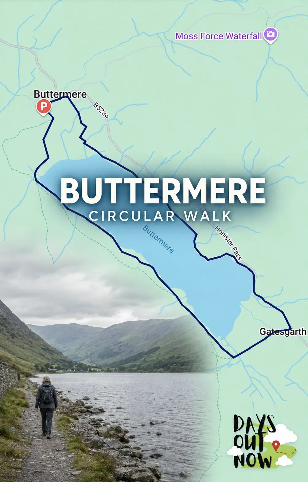
Circle one of the Lake District’s most beautiful lakes on this wonderfully rewarding low-level walk. The Buttermere circular walk packs woodland, mountain reflections, a short rock tunnel and huge views towards Haystacks and Fleetwith Pike into 4.5 memorable miles.
At a glance
Why this walking route is worth doing
The Buttermere circular walk is one of those routes that gives you a huge amount of Lake District scenery without asking for a full mountain day. The path circles the lake beneath Haystacks, High Stile and Fleetwith Pike, with the view changing every few minutes.
This is a low-level route rather than a fell climb, but it still feels like a proper adventure. You will cross little footbridges, pass through Burtness Wood, walk beneath steep crags and squeeze through the short Hassness rock tunnel before returning to the village.
Allow around three hours so you can stop for photographs and enjoy the quieter corners of the shore. The complete circuit includes uneven and sometimes muddy ground, a brief roadside section and one short rock step where you may need to use your hands.
Buttermere circular walk at a glance
- Route type: Circular lakeshore walk
- Distance: 4.5 miles / 7 km
- Time: Around 2.5-3 hours
- Start and finish: Buttermere village car park
- Terrain: Lakeshore paths, woodland, stones, gates, footbridges, one short road section and a brief rock step
- Main highlights: Buttermere Dubs, Burtness Wood, views of Haystacks and Fleetwith Pike, Peggy’s Bridge, Gatesgarth and the Hassness tunnel
This guide follows the loop anti-clockwise, leaving the village for the western shore first and returning along the eastern shore. The lake stays close for most of the walk, so navigation is generally straightforward, but take the interactive map and an offline map with you.
Good to know: Moss Force appears on the wider poster map, but it is not part of this 4.5-mile circuit. It is a separate stop on Newlands Pass if you want to extend your day by car.
Mapped and ready
See the real route before you set off
Open the interactive map before setting off and save an offline map for the walk.
Step-by-step directions
Follow the route
Buttermere village to the lake
From the village car park, walk back towards Buttermere Court Hotel and follow the signs for the lake. Continue along the bridleway. After roughly 200 metres, ignore the turning signed for Scale Force and take the lane that drops towards the shoreline.
Parking or booking: Use the pay-and-display village car park behind Buttermere Court Hotel; arrive early because spaces are limited.
Buttermere Dubs and the western shore
Turn right near the shore and follow the clear path towards the footbridges at Buttermere Dubs. Cross the bridges, pass through the gate and enter Burtness Wood. This first section quickly opens up the classic view along the lake towards Fleetwith Pike.
Through Burtness Wood
Stay with the main lakeshore path as it winds through the trees. The ground becomes rougher and more undulating in places, with stones, roots and wet patches after rain. Where the path pulls slightly away from the water, keep following the obvious through-route around the lake.
Towards Scarth Gap and Peggy’s Bridge
Continue south-east with Buttermere on your left. At the junction with the Scarth Gap path, turn left through the gate and cross Peggy’s Bridge. The path leads towards Gatesgarth Farm at the head of the valley, directly beneath some of the biggest scenery on the walk.
Gatesgarth and the short road section
Follow the signed path past Gatesgarth and join the B5289 for the brief roadside section. Keep well in, watch carefully for traffic and keep children and dogs close. Leave the road as soon as the signed lakeshore path returns on your left.
Route advice: Keep well in on the brief B5289 section and keep children and dogs close.
The eastern shore and Hassness tunnel
Follow the path north-west along the eastern side of Buttermere. This shore feels wonderfully tucked beneath the crags and includes the short, dark tunnel cut through the rock near Hassness. A phone torch can be useful, although the tunnel is only brief.
Route advice: A phone torch is useful for the short Hassness rock tunnel.
The rock step and return to the village
Continue on the lakeshore path, taking care on rocky or slippery sections. The full circuit includes one short rock step where you may need to use your hands. Stay with the main path as it rounds the northern end of the lake, then follow the lane back into Buttermere village and the car park.
Route advice: Take care on slippery rock; the short step may require the use of your hands.
Bookable experiences
Activities that fit this guide
Ideas for another day or a longer break. Allow a separate day for these tours; do not plan them after this walk.
Find more experiences around the Lake District
Lake District
Turn the walk into a bigger Lake District break with a guided tour, lake cruise or another local experience. Check the latest activities and availability before you travel.
Browse Lake District experiencesActivity links are affiliate links. Days Out Now may earn a commission at no extra cost to you. Check the provider’s current description, location and terms before booking.
Useful overnight bases
Places to stay near the route
Buttermere
Buttermere, Cumbria, United Kingdom
Compare places to stay →Accommodation links are affiliate links. Days Out Now may earn a commission at no extra cost to you. Prices and availability are set by the booking provider.
Before you go
Practical information
Footwear and conditions
Wear walking shoes or boots with a reliable grip. Although this is a low-level route, woodland and lakeshore sections can be muddy, wet and slippery after rain. Lake District weather changes quickly, so carry a waterproof and an extra layer even when the start looks settled.
Parking and facilities
The pay-and-display village car park is just beyond and behind Buttermere Court Hotel. It has limited spaces, so arrive early on sunny weekends, bank holidays and during school holidays. Paid public toilets are nearby, with food and drink available in Buttermere village. Check opening times before relying on any one business.
Dogs
Dogs are welcome in the Buttermere Valley, but livestock are common. Keep your dog on a short lead around sheep, cattle and farm areas, and under close control throughout. Take waste home where bins are not available.
Children, pushchairs and accessibility
This can be a brilliant family walk for children who are comfortable covering 4.5 miles on uneven ground. Take extra care beside the road and around the rock step. The full circular route is not suitable for ordinary pushchairs or most wheelchair users because of rough surfaces, narrow sections and the rock step.
A shorter out-and-back option from Buttermere village follows the western shore towards Gatesgarth and avoids committing to the full loop. The Lake District National Park grades parts of that route as Miles Without Stiles “for some”, but visitors should still check the detailed access information against their own needs before setting out.
Travel and safety
The seasonal 77 and 77A Honister Rambler services connect Buttermere with Keswick and also stop at Gatesgarth, which can make a shorter linear walk possible. Check the current timetable before travelling. Mobile signal can be unreliable in the valley, so load the map before you arrive and do not rely on your phone alone.
Protect this special place by staying on the established path, taking litter home and leaving gates as you find them. If the lake is high, the weather is poor or any path is closed, follow local signs and turn back rather than forcing the route.
Parking
Use the pay-and-display village car park just beyond and behind Buttermere Court Hotel. Spaces are limited and it fills quickly at busy times. Paid public toilets are nearby.
Tickets and booking
No ticket is required. The village car park is pay-and-display with limited spaces, so arrive early on sunny weekends, bank holidays and school holidays.
Seasonal considerations
Lake District weather changes quickly. Carry waterproofs and an extra layer throughout the year, and expect wetter, muddier paths after rain.
Toilets and refreshments
Paid public toilets and refreshments are available in Buttermere village. Carry water and check local opening times before starting.
Terrain
Lakeshore paths, woodland, stones, gates, footbridges, one brief roadside section, a short rock tunnel and one rock step. Mud and slippery ground are common after rain.
Accessibility
The full circuit is not suitable for ordinary pushchairs or most wheelchair users because of rough surfaces, narrow sections and the rock step. Parts of the western shore may suit some visitors; check current Miles Without Stiles information.
Facilities
Paid public toilets and food and drink are available in Buttermere village. Check opening times before relying on any one business.
Dogs
Dogs are welcome in the valley, but livestock are common. Keep dogs on a short lead around sheep, cattle and farm areas, and under close control throughout.
Public transport
Seasonal 77 and 77A Honister Rambler services connect Buttermere with Keswick and stop at Gatesgarth. Check the current timetable before travelling.
Road conditions, tolls or permits
The route has a short section beside the B5289. Keep well in, watch for traffic and keep children and dogs close until the signed lakeshore path resumes.
Safety
Wear footwear with grip, carry a torch for the short tunnel, download the map because signal is unreliable, and turn back if high water, poor weather or a closure makes the route unsafe.
Important cautions
Take extra care on the brief B5289 roadside section, at the rock step and beside high water. Follow local signs and turn back if paths are closed or unsafe.
Days Out Now Free Travel Club
Take the useful bits with you
Join free for GPX route files and access to Days Out Now member benefits, including eligible days-out savings.
Useful answers
Buttermere Circular Walk FAQs
How long is the Buttermere circular walk?
The complete Buttermere circular walk is approximately 4.5 miles, or 7 km. Most people should allow around 2.5 to 3 hours, with extra time for photographs, food stops and slower family groups.
Is the Buttermere circular walk difficult?
It is an easy-moderate low-level walk rather than a mountain climb. Most of the route is straightforward, but there are rough and muddy sections, a brief stretch beside the road and one short rock step where you may need to use your hands.
Where do you park for the Buttermere circular walk?
Use the pay-and-display village car park just beyond and behind Buttermere Court Hotel, Buttermere, CA13 9XA. Spaces are limited and fill quickly at busy times, so arriving early is sensible. Paid public toilets are nearby.
Can children walk around Buttermere?
Yes, it can be a lovely family route for children who are confident on uneven paths and able to manage 4.5 miles. Adults should supervise closely on the short road section, near the water and at the rock step.


For local businesses
Own somewhere visitors should discover near Buttermere, Lake District?
Showcase a relevant place to stay, food stop, attraction or activity while Days Out Now keeps editorial control.


Leave a Reply